I often seek out books and articles to garner some background detail for my family history research. Most recently, I came across Frederick Davis’ The History of Luton with Its Hamlets etc (1855). It has been fully digitised by Google Books. I had a brief read through the work, which deals with eminent local names, and includes chapters on schooling, local religion and descriptions of public buildings. There is even a chapter describing indigenous plants and animals. A revised edition titled Luton, Past and Present: Its History and Antiquities appeared in 1874, and includes photographs.
The engravings extracted below include one of the Wesleyan Chapel in Luton (A). The chapel underwent a few incarnations before being rebuilt in 1852, and was extended in the 1880’s. The Wesleyan Day School started in 1853, and existed until the new school board was created in 1877. Other engravings include a depiction of the market in 1835 (B), and views of St Mary Parish Church (C). St Mary’s was situated only a few streets from where my ancestors lived. 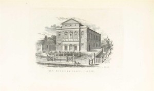 (A)
(A)
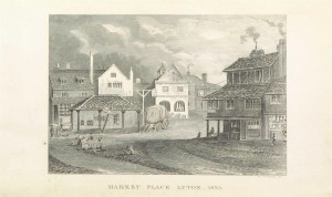 (B)
(B)
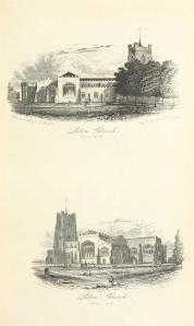 (C)
(C)
Davis describes late-eighteenth century Luton as so narrow that there were few places in which two carts could pass each other. By the time of Davis’ writing, many of the older houses had been rebuilt, with new houses erected and new streets created. After the Public Health Act (1848) was implemented in the 1850’s, a number of civic improvements were made. The first houses in New Town Street (where some of my ancestors would later live) were built in the 1830’s.
Davis’ work is known to contain some errors; much of it is a triumphant description of improvements made to the town by public munificence and an account of its grandees. The work is arranged like a typical nineteenth-century history which narrates the history of Luton from antiquity to its commercial rise. But I found Davis interesting to read. His anecdotes give the work some character and it contains topographical descriptions of Luton’s surrounding hamlets, as well as some mention of local custom.
Viewing the topography of nineteenth-century Luton is fascinating as it gives an impression of various aspects of my ancestors’ everyday life such as places of education, leisure and work. The proximity of the narrow streets surrounding St Mary’s Church, shows the small area occupied by most of the people of Luton. Unsurprisingly, many of my relatives are recorded as living only a few streets apart from who they would later marry. My ancestors migrated to Luton from its rural surroundings during its mid-century commercial growth; the majority becoming workers in the booming Straw Hat industry. Luton’s expansion was boosted by the arrival of the railway. This comes into focus near the end of the work, which details local proposals for a new railway line.
References
* Bedfordshire and Luton Archives and Records Service, ‘Chapel Street Wesleyan Church Luton’, http://www.bedfordshire.gov.uk/CommunityAndLiving/ArchivesAndRecordOffice/CommunityArchives/Luton/NonconformityinLuton/ChapelStreetWesleyanChurchLuton.aspx, Accessed 26/12/2013.
* Frederick Davis, The History of Luton with Its Hamlets etc, (1855). [The work was printed for the author by J. Wiseman of George Street.]